Why aid workers should be trained in satellite technology
Satellite solutions are quickly becoming a vital tool in disaster response, but how much do individual aid workers need to know about them?
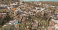
BARCELONA — When a natural disaster or crisis hits, access to information is critical for those responding. Increasingly, satellites are being used to plug information gaps — providing communication via satellite phones, generating maps of affected areas through satellite imagery, and providing location services through satellite-enabled navigation applications. However, experts told Devex that even as reliance on satellite technology grows, many aid workers are still not familiar with how it works and how it should be used — and this can sometimes get in the way of disaster response. Satellites have changed the way some organizations do disaster response and the services they’re able to provide to those affected, said Noe Hatchuel, senior international emergency field operations officer at the American Red Cross. “It has real impact, it saves lives, and alleviates human suffering,” he said. For the American Red Cross, the use of satellites — particularly imagery — goes beyond immediate disaster response to the planning and monitoring of recovery projects post-crisis. “We can use imagery to see how agricultural lands are recovering, how flood waters are receding, how communities are rebuilding, and watch it to literally see roofs go up,” said Hatchuel, adding that satellites are now as much a part of preparedness, response, and recovery as planning, telecommunication, and security. In Nepalese hospitals, Hatchuel explained that satellites had enabled staff to send X-ray images to hospitals in Tokyo for remote consultations post-earthquake, and in Puerto Rico, satellite-based communications helped reconnect families as part of a reunification program. Amnesty International has also been using satellite imagery to document human rights abuses. Following the recent bombing of the Tajoura migrant detention center in Tripoli, for example, staff were able to see the extent of the damage using satellite imagery just 12 hours after the attack. Micah Farfour, a remote sensing advisor, explained that it is often safer to view the images remotely than to put researchers on the ground. Satellites can also provide real-time information and allow researchers to work more efficiently; should they later visit the location, they can travel directly to the damaged areas rather than having to first identify where they are. Of the American Red Cross’s deployed staff, everyone has some level of knowledge around satellites, said Hatchuel, even if it’s just the basics. “These [satellites] are an essential piece of our tool kit … Ideally, 100% [of staff] have been trained to interact with a satellite-based system.” But across the humanitarian sector, that’s not always the case — and it can be a problem. “Our members reported one incident where a country believed it was prepared, as they had plenty of satellite phones, but when they tried using them, they couldn’t connect,” explained Aarti Holla-Maini, secretary-general of the EMEA Satellite Operators Association, one of the founding signatories of the Crisis Connectivity Charter — a set of commitments made by the satellite community to the U.N. Emergency Telecommunications Cluster to improve connectivity in times of crises and facilitate communications between emergency responders. “Why? Because satellite phones will not work inside a building,” she said. “They hadn’t remembered in the stress of the situation that terminals like satellite phones actually need a 'line of sight' to the satellite in space, which means they typically need to be used outside.” Such scenarios demonstrate why training for aid workers on satellite technology is crucial, said Holla-Maini. Even for those who aren’t engaging with satellites — whether it be imagery or communication — on a regular basis, some knowledge can be helpful, said Farfour. It can be easy to misinterpret satellite imagery if not fully trained on how to examine it. “Oftentimes people don’t know what a burnt infrastructure looks like compared to a shadow, or if it’s an anomaly in the image, or if the angle it was taken [from] makes it look a bit strange. Those are simple things, but can lead to strong misinterpretations,” she said. Amnesty International teaches its researchers on the ground how to identify coordinates, study maps, and work with witnesses to identify locations so that staff such as Farfour working remotely are able to match those locations with the most recent imagery. “For us, it adds another level of information we might be able to use,” said Farfour. It doesn’t always need to be the most technically minded staff who are trained, said David Meltzer, secretary general of the Global VSAT Forum, or GVF, a nonprofit association that facilitates access to satellite-based connectivity solutions. He advised that local staff are the ones likely to derive the most benefits from it. As the ones on the ground, they’ll be able to respond quicker and are best positioned to establish connections with local government in case any equipment from overseas needs to be brought in and clear customs. Such training can also be an additional source of income for individuals given its marketability as a skill, he added. A number of organizations — such as GVF; UNOSAT, the U.N. satellite training program; and the Emergency Telecommunications Cluster, a network of groups working to provide communications services in emergency situations — run courses around satellite imagery, geospatial information technologies, and disaster mapping for those working in the humanitarian sector. And it doesn’t need to cost the earth, said Meltzer, explaining that prices of courses and equipment are dropping as technology improves. “The training costs only a couple hundred dollars, depending on the level. Equipment can certainly be inexpensive, and the leasing of satellite equipment on an ad-hoc basis can be anywhere from inexpensive to free,” he said. GVF — which also offers online training and mentorship to make courses more accessible — offers membership of its Knowledge Center with access to training for $348. It is also a signatory to an agreement between the Crisis Connectivity Charter and satellite organizations to provide free satellite connectivity and “pre-allocated bandwidth capacity for humanitarian purposes” that can be activated within 24 hours of a crisis, covering all regions of the globe. Satellite communication is “not for everyone,” said Meltzer, but “I would encourage any international NGO in need of international communication links to look at the satellite option.” Particularly in remote locations, it is often the “most effective and cost-effective way of communicating,” he said.
BARCELONA — When a natural disaster or crisis hits, access to information is critical for those responding. Increasingly, satellites are being used to plug information gaps — providing communication via satellite phones, generating maps of affected areas through satellite imagery, and providing location services through satellite-enabled navigation applications.
However, experts told Devex that even as reliance on satellite technology grows, many aid workers are still not familiar with how it works and how it should be used — and this can sometimes get in the way of disaster response.
Satellites have changed the way some organizations do disaster response and the services they’re able to provide to those affected, said Noe Hatchuel, senior international emergency field operations officer at the American Red Cross.
This story is forDevex Promembers
Unlock this story now with a 15-day free trial of Devex Pro.
With a Devex Pro subscription you'll get access to deeper analysis and exclusive insights from our reporters and analysts.
Start my free trialRequest a group subscription Printing articles to share with others is a breach of our terms and conditions and copyright policy. Please use the sharing options on the left side of the article. Devex Pro members may share up to 10 articles per month using the Pro share tool ( ).
Rebecca L. Root is a freelance reporter for Devex based in Bangkok. Previously senior associate & reporter, she produced news stories, video, and podcasts as well as partnership content. She has a background in finance, travel, and global development journalism and has written for a variety of publications while living and working in Bangkok, New York, London, and Barcelona.