I was in the driver’s seat in conceptualizing and helping consensus building for the Sustainable Development Goals, and one of the central challenges is in how to monitor and review the goals, targets, and indicators for this wonderful framework for peace, prosperity, planet, and our people.
A key aspect of the 2030 agenda is focusing on interlinkages between the various goals: As we in the United Nations and the global development community work toward assisting countries in reaching the targets, we need to identify good tools, while at the same time making sure to leave no country behind. This is where satellite imagery comes in.
Due to the very nature of this information source — with satellites constantly orbiting the Earth — we can collect data globally and predictably. Hence, we have global data for global goals.
Evidence supported by objective data is key for designing, monitoring, and reviewing intelligent policy, and satellite imagery analysis is a key method of gathering such data — at the global, regional, and local level. Some recent examples of these multiple applications of satellite imagery include the struggle for accurate information relative to COVID-19, and the use of imagery in fighting environmental degradation, managing conflicts, migration, and even economic prosperity.
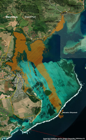
The figure below shows a satellite image derived oil spill analysis in Mauritius following a bulk carrier incident as of Aug. 15.
Another example is the use of satellite imagery during conflict situations. During the Syria conflict, the Al Zaatari refugee camp quickly grew into Jordan’s fourth largest city over a period of less than two years, reaching 156,000 inhabitants in March 2013. Hence, detailed camp planning and monitoring of its growth was essential, which was achieved using satellite imagery.
How satellite imagery benefits sustainable development
There are many studies on how satellite imagery serve for a wide range of SDGs, such as reports by the Committee on Earth Observation Satellites and European Space Agency, the Group on Earth Observations, as well as GEO, and the U.N. Committee of Experts on Global Geospatial Information Management.
There are four key benefits of using satellite imagery for sustainable development:
1. Global coverage
Satellite imagery is one of a very few sources of information that ensures data collection all over the world. This becomes particularly important in rural areas and in areas with very low population density. Also, for areas located far from capitals which can be difficult — if not impossible to get to physically — satellite imagery collects information the same way as in densely populated areas, hence collecting consistent data.
During the COVID-19 pandemic it also became obvious that even if areas are accessible in principle, they have been neglected due to travel restrictions. Satellites keep collecting much needed information in all circumstances.
As an example, following tropical Cyclone Harold in the Pacific, satellite imagery was used to identify damage in the Pentecost Island, Vanuatu. This was particularly useful as communication systems were affected by the cyclone and so only limited information on the damage was available to national authorities. Thanks to the satellite imagery analysis, national emergency managers could assess the damage from remote and make the necessary priorities.
More from the Space Data for Development series:
► How user-friendly satellite data could revolutionize development
► How mapping skills can drive progress on the SDGs
► Mapping Makoko: How data could help legitimize Nigeria's informal settlements
2. Monitoring over time
When conducting trend analysis, which is often needed to assess and plan sustainable development policies, it is important to track changes over time. Satellite imagery provides historic evidence, in some instances going back to the mid-1970s.
Currently, every point of Earth — except for the high latitudes — is imaged at least once per day from satellites, ensuring a sufficient level of detail for many of the SDG indicators. Hence, we have access to an extraordinary archive of images to monitor changes over time. For example, significant urban development has been observed over Shanghai using satellite imagery from 1985 and compared with the current situation.
3. Objective information source
To compare SDG indicators for different countries, it is important that information is collected in an objective manner. Due to the very nature of satellite imagery, which collects the same data all over the world, the same peer-reviewed scientific methods can be applied, ensuring transparency and objective information validation.
This was recently applied to monitor the effects of the COVID-19 lockdowns on air-pollution. Using the same dataset, one saw similar patterns of significantly reduced pollution in cities such as Bangkok, Guatemala City, Paris, Beijing, and Cape Town.
4. Cross cutting benefits
The 2030 agenda is based on five main pillars: peace, planet, people, prosperity, and partnerships, with satellite imagery being fully applicable to the thematic pillars. Imagery from the same satellite can be used to monitor peace missions (peace), to document deforestation (planet), to monitor agriculture production (people), and to map rural population distribution (prosperity).
This important cross-cutting function complements and contributes to the work of traditional national statistical offices.
The way forward
To allow all countries to benefit from satellite imagery, we need to ensure that their internal capacity and know-how is enhanced. The good news is that much of the imagery and imagery-derived information is available free of cost.
Hence, the focus needs to be on how to make the best use of this information at national level. This requires understanding national information needs and the transfer of relevant knowledge to meet these needs, for example through partnerships and knowledge exchanges.
The CommonSensing project, funded through the International Partnership Programme of the UK Space Agency, is one example, where we have placed UNITAR-UNOSAT technical experts with the governments of Fiji, Vanuatu, and the Solomon Islands, learning from the needs of the governments and transferring the skills needed — in this case, to become more resilient to climate change.
I would urge governments to ensure satellite imagery is more widely used by making full use of the technology through partnerships and knowledge exchange.
Through technical assistance and support we must make sure no one gets left behind when it comes to making use of global data for global goals.
Visit the Data for Development series for more coverage on practical ways that satellite data can be harnessed to support the work of development professionals and aid workers. You can join the conversation using the hashtag #DataForDev.
About the author

Nikhil Seth
Nikhil Seth is assistant secretary-general and executive director at the United Nations Institute for Training and Research.